Midland Basin | Permian
A Comprehensive Guide to the Permian’s Midland Basin, Featuring Subsurface information, Regional Facts & Statistics
Midland Basin Overview
Once considered home to the world's largest unrecoverable oil reserves due to its tight rock formations, the Midland Basin has become a dominant force in US production since the introduction of hydraulic fracturing techniques in the early 21st century. The following sections provide details about the Midland Basin’s production capacity, major geological structures, market activity, and regional population.
What is the Midland Basin?
The Midland Basin boasts the first discovery well and first commercial well of the Permian Basin. Its geology can be thought of as a mirror image of the Delaware, dipping towards the west where it is bounded by the Central Basin Platform. The basin is shallower and less overpressured compared to the Delaware, even along its axis, and is not as pervasively faulted as its western analogue. Similar to the Delaware, historical development focused on shallower detrital sandstone and carbonate targets sourced from the basin’s peripheral features and deposited during Early Permian Epoch, referred to as the Spraberry group in the Midland. Modern development in the basin is focused on the organic-rich units within the Wolfcamp and Spraberry groups. Horizontal drilling and hydraulic fracturing technologies effectively quadrupled the Midland Basin's production in 2012.
What Natural Resources are in the Midland Basin?
In addition to its vast oil and gas reservoirs, there are a wide variety of subsurface natural resources in the Midland Basin region, including major sylvite formations that yield a steady supply of potassium salts (potash), a byproduct of which is rock salt. Given the high water cut in some Midland Basin formations, produced water is a valuable natural resource that operators must treat and reinject or recycle for use in hydraulic fracturing or even irrigation.
Buying or selling assets in the Permian?
Wolfcamp Formation / Wolfcamp Play
With a thickness up to 1,000 feet, the Wolfcamp Formation is the deepest in the center of the Midland Basin where it is about 12,000 feet deep compared to depths that vary from 4,000 to 7,000 feet at the edges of the basin. Modern drilling techniques have unlocked its vast reservoirs of high-quality shale oil, making it the primary target of Midland Basin development.
Midland Basin Oil Production
In 2012, the introduction of horizontal drilling dramatically increased Midland Basin oil output from approximately 350 Mbbl/d to 1.9 MMbbl/d at the beginning of 2020. While the basin’s path to modern unconventional development was paved by operators in the shallower southern end of the basin, rapidly increasing gas-oil-ratios characteristic of the basin have made the area unfavorable economically compared to the deeper, oilier northern end of the basin where most current activity is located.
Decreasing horizontal and vertical spacing between parent and child wells coupled with cemented carbonates in the subsurface are leading companies to investigate interwell pressure communication across zones in order to mitigate the economic impact of hydraulic fracturing on producing wells (frac hits).
Map of the Midland Basin
The Midland Basin spans roughly 14,000 square miles in west Texas. It is separated from the Delaware Basin by the Central Basin Platform on the west and in the east the basin transitions to the Eastern Shelf, a platform carbonate feature where conventional resource has been extensively exploited. In the south, the Midland Basin is separated from the Val Verde subbasin by the Ozona Arch.
Historical and Emerging Targets in the Midland Basin
The Midland Basin has the honor of being the site of the first discovery well of the Permian, drilled in Mitchell County in 1920. According to the Texas State Historical Association, the first commercial oil well of the Permian was Santa Rita #1 (named after the patron saint of the impossible), which was completed in Reagan County in 1923 within the San Andres Formation at a depth of 3,050 feet and produced until 1990. For the bulk of the 20th century, operators targeted the San Andres and Spraberry Formations with vertical wells. Legacy vertical wells tapped into the stacked pay zones of the basin by completing zones in the Lower Spraberry and Wolfcamp benches, a comingling of production once known as Wolfberry.
Today, operators primarily target the Wolfcamp’s rich oil shales with horizontal drilling and hydraulic fracturing. The Eastern Shelf has also seen recent activity from wildcatters while newly discovered oil and gas reserves in the Val Verde Basin are sure to draw even more drilling activity to the southeast end of the Midland Basin.

What are the Formations of the Midland Basin?
The formations of the Midland Basin are mainly comprised of carbonate reef deposits and shallow marine clastic sediments. From youngest to oldest (or shallowest to deepest), the formations of the Midland Basin include Tansill, Yates, Seven Rivers, Queen, Grayburg, San Andres, Glorieta, Leonard, Spraberry, Dean, and Wolfcamp.
14
13
11
10
15
16
6
5
1
2
3
4
8
7
9
12
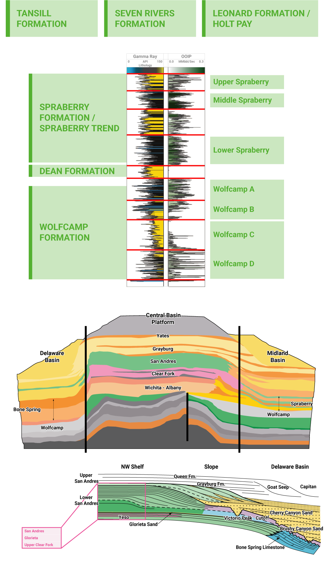
Tansill Formation
With a thickness between 120 and 320 feet, the Tansill Formation is the shallowest of the Central Basin Platform formations. It is comprised of limestone, siltstone, and anhydrite spanning west Texas and southeastern New Mexico.
Seven Rivers Formation
Ranging in thickness from 400 to 2,000 feet, the Seven Rivers Formation is comprised of anhydrite with interbeds of dolomite, sandstone, siltstone, and shale. As with most of the upper CPB formations, it is part of the Artesia Group, a sequence of shelf rocks in the Capitan reef.
Leonard Formation / Holt Pay
The Leonard Formation, sometimes referred to as the Holt Pay, is a producing zone capping the upper Spraberry Formation with a thickness up to 350 feet. It is comprised mainly of anhydritic dolomite with interbedded sandstone.
Spraberry Formation / Spraberry Trend
Characterized by alternating shale and sandstone layers, the Spraberry Formation, also known as the Spraberry Trend, is ranked as the third largest oilfield in the US. It is not considered a "true shale," comprised mainly of fine-grained sandstone and siltstone with interspersed silty shales. It has a total thickness of 1,100 feet and is subdivided into three intervals.
Upper Spraberry
The Upper Spraberry is the least targeted interval largely due to variances in porosity and permeability, and is very shallow.
Middle Spraberry
The Middle Spraberry is an emerging target with similar geologic characteristics to the Lower Spraberry, though is shallower stratigraphically. It is separated from the Lower Spraberry by the Jo Mill submarine-fan system and is 350 feet thick.
Lower Spraberry
With a thickness up to 500 feet, the Lower Spraberry formation is the most targeted of the Spraberry intervals and of the Midland Basin. It is characterized by carbonate and shale layers. Wells drilled in the Lower Spraberry are as much as three times more productive than the Upper Spraberry.
Dean Formation
The Dean Formation lithology is primarily a high porosity sandstone that is also highly water saturated. Thickness of the Dean Formation varies between 200 and 800 feet.
Wolfcamp Formation
The Wolfcamp Formation is primarily characterized by thick, organic rich shales, with varying amounts of siliciclastic and carbonate influence, in response to sea level fluctuations over millions of years. In the Midland Basin, the Wolfcamp is subdivided into four benches.
Wolfcamp A and B
The Wolfcamp A and B are characterized by a highly organic rich and resource dense shales and are the most targeted intervals in the Permian.
Wolfcamp C and D
The Wolfcamp C and D are less prospective targets than the Upper Wolfcamp, though combined are over 1,000 feet thick.
Yates Formation
Underlying the Tansill Formation, the Yates Formation is similarly comprised of siltstone, anhydrite, and very fine sandstone with large quartz grain inclusions. It's average thickness is approximately 260 feet.
Grayburg Formation
The Grayburg Formation has an average thickness of approximately 300 feet. From top to bottom, it is comprised mainly of layers of dolomite, sandy dolomite, and sandstone with intermittent anhydrite interbeds.
San Andres Formation
Conformably overlain by the Grayburg Formation, the San Andres Formation is comprised of marine limestone with a maximum thickness of 1,300 feet. The San Andres Formation has been the primary target of oilfield development in the CPB since the early 1920s.
Queen Formation
Underlying the seven Rivers Formation, the Queen Formation is comprised of sandstone with infrequent interbeds of anhydrite and dolomite. The Queen Formation has a maximum thickness of 500 feet.
Glorieta Formation
The Glorieta Formation is a mature quartzarenite sandstone. Approximately one third of the Glorieta Formation is trough-crossbedded sandstone with about a quarter of the Formation characterized by wind-ripple laminated sandstone.
Adjoining Basins and Notable Features of the Midland Basin
In addition to its core formations, the Midland Basin features a number of nearby adjoining geologic features or basins.
Eastern Shelf
To the east of the Midland Basin is the Eastern Shelf of the Permian, a relatively small area featuring a conventional, stratigraphic trap within Scurry County, Texas. With lower cost acreage compared to prime positions to the west, the Eastern Shelf offers private E&Ps and wildcatters emerging horizontal drilling opportunities as evidenced by the increase in rig count over 2016 levels.
Val Verde Basin
Separated by the Ozona Arch and directly south of the Midland is the Val Verde Basin, which is roughly 25 miles wide by 150 miles long. With sediments deposited during a long period of flooding during the Middle to Late Cretaceous, the Val Verde Basin is estimated to hold as much as 5 trillion cubic feet of natural gas and is an emerging major gas producer in the Permian.
Midland Basin Rig Count
Visitors to Midland, Texas are often greeted by lines of drilling rigs ready to deploy to the Midland Basin. Given the extensive target depths for the Wolfcamp and Spraberry Formations, these rigs represent some of the highest performing land drilling rigs with rotary and directional capabilities that demand high day rates.

U.S. Rig Count
521
2% ↑ change from previous week.
Last updated 2021-06-02.
Pipelines of the Midland Basin
Given its long history and continuous oil production since the early 1920s, the Midland Basin has many of the oldest gathering and transportation pipelines in the Permian representing the basin’s early success. In response to the takeaway capacity needs of the Midland Basin’s revitalization following the advent of unconventional drilling in the last decade, the pipelines of the Midland Basin also include a network of newer oil, gas, and produced water transportation pipelines.
Midland Basin Oil Companies
The stacked pay zones and prime acreage positions of the Midland Basin have attracted the supermajors and leading publicly traded firms. Midland Basin oil companies also include many smaller independent exploration and production companies. The following table lists top oil companies of the Midland Basin by barrel of oil equivalent (BOE).
|
Operator |
Oil (Mbbl) |
Gas (Mmcf) |
BOE (Mboe) |
|
717 |
1,800 |
1,000 |
|
|
228 |
704 |
345 |
|
|
216 |
540 |
306 |
|
|
168 |
728 |
290 |
|
|
759 |
369 |
254 |
|
|
185 |
375 |
248 |
|
|
151 |
425 |
222 |
|
|
145 |
444 |
219 |
|
|
89 |
551 |
181 |
|
|
114 |
287 |
161 |
|
|
105 |
281 |
151 |
|
|
98 |
252 |
140 |
|
|
99 |
205 |
134 |
|
|
72 |
211 |
107 |
|
|
53 |
312 |
105 |
Counties of the Midland Basin
The counties of the Midland Basin extend from Lynn County, Texas, in the north down to Crockett County, Texas. Spanning large tracts of sparsely populated acreage, the Midland Basin’s most populous counties are in neighboring Midland County and Ector County.
|
County |
State |
Population |
Land Area (miles) |
Land Area (kilometers) |
Surface Water |
|
Texas |
14,057 |
1,501 square miles |
2,416 km2 |
0.02% |
|
|
Texas |
525 |
906 square miles |
1,458 km2 |
1.00% |
|
|
Texas |
3,310 |
911 square miles |
2,359 km2 |
1.75% |
|
|
Texas |
4,165 |
786 square miles |
1,265 km2 |
0.08% |
|
|
Texas |
3,560 |
2800 square miles |
7300 km2 |
0.20% |
|
|
Texas |
13,657 |
902 square miles |
1,452 km2 |
0.20% |
|
|
Texas |
134,165 |
902 square miles |
1,452 km2 |
0.50% |
|
|
Texas |
15,382 |
1,503 square miles |
2,419 km2 |
0.03% |
|
|
Texas |
1,406 |
901 square miles |
1,450 km2 |
0.10% |
|
|
Texas |
32,940 |
904 square miles |
1,455 km2 |
0.40% |
|
|
Texas |
1,600 |
1,052 square miles |
2,725 km2 |
0.07% |
|
|
Texas |
4,581 |
916 square miles |
1,474 km2 |
0.08% |
|
|
Texas |
176,832 |
902 square miles |
1,452 km2 |
0.28% |
|
|
Texas |
8,470 |
911 square miles |
2,359 km2 |
0.50% |
|
|
Texas |
3,710 |
1,175 square miles |
3,043 km2 |
0.05% |
|
|
Texas |
2,983 |
640 square miles |
1,660 km2 |
1.30% |
|
|
Texas |
1,300 |
923 square miles |
2,392 km2 |
0.07% |
|
|
Texas |
3,770 |
1,454 square miles |
3,766 km2 |
0.05% |
|
|
Texas |
110,000 |
1,541 square miles |
3,991 km2 |
0.06% |
|
|
Texas |
3,130 |
1,242 square miles |
1,999 km2 |
0.01% |
Cities of the Midland Basin
The cities of the Midland Basin include Big Lake, the oldest oil town in the Permian (named after the oil company by the same name following the 1923 drilling of the Santa Rita #1 well in Reagan County and subsequent oil boom in the area). Midland Basin cities range in population size from more than 340,000 in the Midland/Odessa metropolitan area to 300 in Garden City, Texas.
|
City |
State |
County |
Population |
Land Area (miles) |
Land Area (kilometers) |
|
Texas |
Lubbock County |
254,000 |
136 square miles |
352 km2 |
|
|
Texas |
Midland County |
136,000 |
75 square miles |
194 km2 |
|
|
Texas |
Tom Green County |
93,200 |
61.9 square miles |
160 km2 |
|
|
Texas |
Val Verde County |
36,000 |
20.5 square miles |
53 km2 |
|
|
New Mexico |
Eddy County |
28,800 |
31.5 square miles |
81.5 km2 |
|
|
Texas |
Howard County |
27,900 |
19 square miles |
49 km2 |
|
|
Texas |
Hale County |
20,800 |
13.8 square miles |
35.74 km2 |
|
|
Texas |
Terry County |
9,720 |
6.55 square miles |
16.9 km2 |
|
|
Texas |
Dawson County |
9,210 |
5.14 square miles |
13.31 km2 |
|
|
Texas |
Lamb County |
5,990 |
6.28 square miles |
16.27 km2 |
|
|
Texas |
Mitchell County |
3,940 |
5.33 square miles |
13.81 km2 |
|
|
Texas |
Reagan County |
3,240 |
2.39 square miles |
6.19 km2 |
|
|
Texas |
Martin County |
2,950 |
1.98 square miles |
5.12 km2 |
|
|
Texas |
Sutton County |
2,770 |
2.22 square miles |
5.75 km2 |
|
|
Texas |
Schleicher County |
1,690 |
54 square miles |
139 km2 |
|
|
Texas |
Coke County |
1,030 |
1.15 square miles |
2.97 km2 |
|
|
Texas |
Sterling County |
993 |
0.98 square miles |
2.54 km2 |
|
|
Texas |
Irion County |
739 |
1.25 square miles |
3.23 km2 |
|
|
Texas |
Borden County |
326 |
2.02 square miles |
5.23 km2 |
|
|
Texas |
Glasscock County |
319 |
1.78 square miles |
4.76 km2 |
{{SixSense_Company_State}}
{{SixSense_Company_City}}
{{SixSense_Company_Country}}
{{SixSense_Company_Name}}
{{SixSense_Company_Address}}
{{SixSense_Company_Zip}}

Vía Fortuna #200, Austin, TX 78746, United States
Toll-free: 1-800-282-4245 2901
© {{CurrentYear}} • All data and information are provided “as is”. • EEO Information • Privacy Policy • Terms & Conditions